Navigating GIS Projects: Insights from ArcGIS Pro
Written on
Chapter 1: Introduction to GIS Project Management
This guide serves as a resource for navigating the complexities of GIS projects, inspired by the book "Mastering ArcGIS Pro" by Maribeth H. Price, published by McGraw Hill. I aim to share my insights as I delve into various chapters, beginning with the foundational aspects of GIS project management.
GIS Project Framework
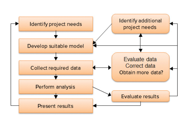
A GIS project can vary significantly in scope, from a brief individual task to a long-term initiative involving multiple stakeholders within a large organization. Regardless of size, these projects typically follow a standard framework, as illustrated in the associated diagram. New users often begin their GIS journey through a project-oriented lens, starting with a needs assessment. Key questions include: What issues need exploration? What information is necessary for informed decision-making? What functions should the GIS perform? What is the expected project duration? Who will benefit from the data? What funding is available for setup and ongoing expenses?

Understanding the intended outcomes of the system is vital for effective design. Users may find critical data lacking or discover resources have been wasted on acquiring unutilized data. In short-term projects, needs are often straightforward. However, in long-term organizational contexts, requirements can change over time, necessitating regular reassessment. A well-structured system accommodates future adjustments, while a hastily built system may require frequent revisions when changes occur.
Model Selection for Data Transformation
In projects aimed at answering specific scientific or management questions, a methodology or model must be chosen. Models convert raw project data into meaningful information through a systematic series of steps and assumptions. For example, a simple model for mapping landslide hazards might classify areas as hazardous if they have steep slopes and consist of shale rock. Geological and slope data layers can then be utilized to create the hazard map. More complex models may also factor in additional elements such as the bedding angle of shale units. Models can range from straightforward to intricate, depending on the inputs and calculations involved.
After identifying needs and designing suitable models, the next step is data collection. GIS data are organized into layers, each representing a specific information type, such as roads or soil classifications. The project's requirements dictate the necessary data layers and their accuracy. Sources for each data layer must be determined. Some data can be sourced from external organizations, while fundamental layers like elevation, roads, waterways, political boundaries, and demographics are often available through governmental channels, albeit with varying precision. More specialized data may need to be created internally; for instance, a utility company might need to develop its own layers for electric lines and substations, as these may not exist elsewhere.
Evaluating Data Precision
Assessing the spatial detail and accuracy of the data is crucial to ensure they meet the project's demands. For example, an engineering firm tasked with creating a site plan for a shopping mall might find that standard 10-foot elevation contours are insufficient. In such scenarios, collaborating with a surveying company to obtain contours at half-foot intervals could be necessary.
Once data assembly is complete, the analysis phase begins. During this stage, challenges often arise, prompting modifications to the model or data. Consequently, the processes of model development, data collection, and analysis frequently become iterative, with lessons learned used to refine future efforts. The final results should be carefully compared against reality to identify any gaps and provide insights for enhancements.
Communication of Results
Ultimately, a project is not truly complete until its results are communicated, whether through informal discussions with supervisors, publication in scientific journals, or presentations at public meetings. Presentations may include maps, reports, slides, or other media.
Chapter 2: Learning from ArcGIS Pro
In this section, we will explore practical insights and tutorials from ArcGIS Pro.
The video titled "Navigator for ArcGIS: Creating Custom Navigation Maps" provides valuable tips on effectively using ArcGIS for customized navigation.
Additionally, the video "Navigating ArcGIS Pro: The Basics Part 2 (The Project View)" covers essential navigation techniques in ArcGIS Pro, helping users to familiarize themselves with the project view.